A Short Selection of Historical Places of Interest in the Parish of Preston, Hertfordshire
by Gilbert Burleigh
The name Preston, Prestun(e), first recorded in a Knights Templar document of 1185, means ‘priests’ farm’. Although not mentioned in the Domesday Book of 1086, the name is Old English (Anglo-Saxon) and the settlement was almost certainly in existence before 1185. Originally it was a hamlet in the parish of Hitchin and the name ‘priests’ farm’ suggests it was a portion of land reserved for the sustenance of the priests serving Hitchin minster church, at that time dedicated to St Andrew.
Temple Dinsley
Almost nothing remains to be seen of the Templars’ buildings except a few glazed and decorated floor tiles (one showing the Agnus Dei, the Lamb of God with a cross and pennant), now in North Hertfordshire Museum, Hitchin, and a decorated grave slab now displayed in St. Martin’s Church, Preston (built 1900). They are all likely to have been originally in the Templars’ chapel. The grave slab is decorated with a floriated cross on its upper side and a simpler cross on its lower. The slab itself is of Purbeck “marble” (actually a highly polished limestone), from the famous quarries on the Purbeck peninsula in Dorset. It is a fine example of its type and dates to around AD 1225-50. The conclusion must be that this slab was the lid of the tomb of a Preceptor (Master) of Temple Dinsley, who died in the mid-13th century. The earliest Preceptor whose name has come down to us is Richard Fitz John, which occurs 1255, so he is a possibility. The tomb would probably have been set within the Templar chapel itself, which was apparently located in the area of the east wing of the College buildings. The slab was probably found during the construction of a kitchen and scullery block in the 1880s (when a human skeleton and a pewter chalice were found, possibly from the tomb associated with the slab), and moved to the church about 1910.
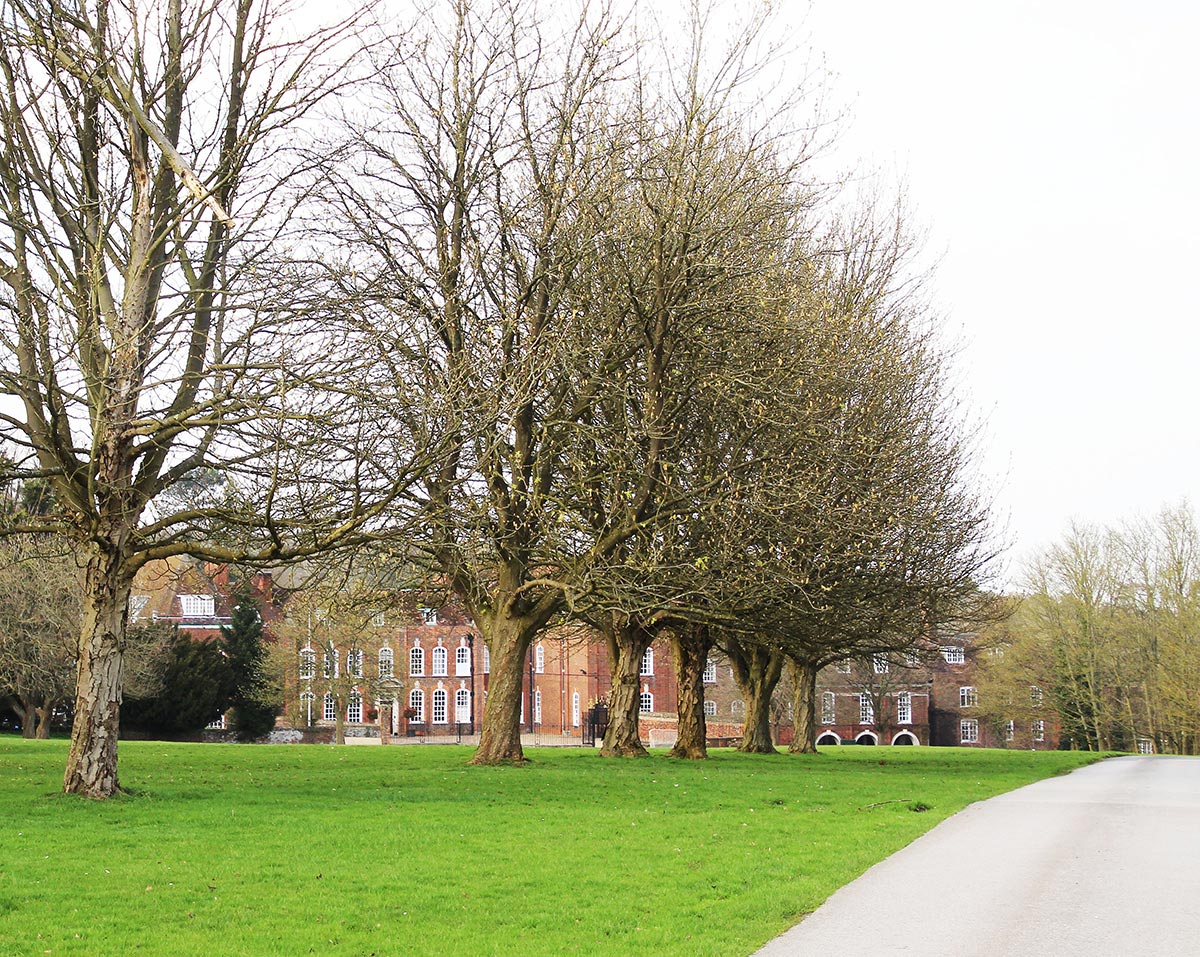
Deneslai is recorded in the Domesday Book of AD1086 as having 19 villagers, 7 smallholders, 7 cottagers, 6 slaves and 1 Frenchman. A population of perhaps 120 – 200, a considerable community by Medieval standards, although perhaps only half lived in a nucleated settlement, the remainder being dispersed around the manorial land. They had 2 (water) mills (one by Dinsley manor house, its pond is there still, the other at Charlton), a meadow, pasture for livestock and woodland for 300 pigs. The manor, then in Hitchin parish, was granted to the Knights Templar in 1142 under the name Dynnesleya. It is Old English and means ‘Dyn(n)e’s clearing or wood’ (or perhaps ‘clearing in the wood’). Princess Helena College now occupies the former manor house (the earliest upstanding part dating from 1714) and site of the Templars’ chapel and preceptory buildings. The Preceptory (something between a manor and a monastery) became the most important in south-east England and Knights Templar national Chapters (meetings) were held there on several occasions, first recorded between 1200 and 1205. By 1300 the Templars had grown rich, and the Hitchin historian, Reginald Hine, wrote that people complained that their wild parties could even be heard in Hitchin, from their almost detached estate centred on Charlton. This is now marked by the place-names ‘Temple End’ and ‘Temple Close’, near the spring at Wellhead, Charlton, the source of the River Hiz.
St. Martin’s church is usually locked when not in use. To see the grave slab contact either Malcolm Lowle, current Churchwarden, at Fig Tree Cottage on The Green : 01462 456664, or Richard Blockley, former Churchwarden, at Lychgate House, Church Lane: 01462 457631. You may view the site of Dinsley by standing at the gateway entrance of the driveway to Princess Helena College, at the junction of School Lane and Crunnell’s Green. Please note that entering is not permitted as it’s a school and private property.
Welei
The location of this deserted village has only been re-discovered in recent years. The 1086 Domesday Book manor of Welei, an Old English name meaning ‘a sacred grove’ or ‘a sacred grove where heathens worshipped’, was occupied by 8 villagers, 5 smallholders, 2 cottagers and 4 slaves, and so was probably a settlement of between 60 – 100 people. Its folk tended 240 acres of arable land, pasture and woodland, where 300 pigs roamed. The site was located by studying old maps of the parish where the place-name Waylay Green is recorded on Bryant’s map of 1822. The manorial records of Temple Dinsley make several references to the fields of Wayley Wick and Wayley Close. In 1845 the manorial documents stated that these two closes were enclosed with Woodclose. The 1818 Enclosure map notes that they straddled a lane then known as Wayley Green Lane, now called Tatmore Hills Lane. Local historian, Nina Freebody, identified the site from map and other documentary sources at TL 174260 and in 1984 she and another local resident, Liz Hunter, collected 11th/12th century potsherds from the site.
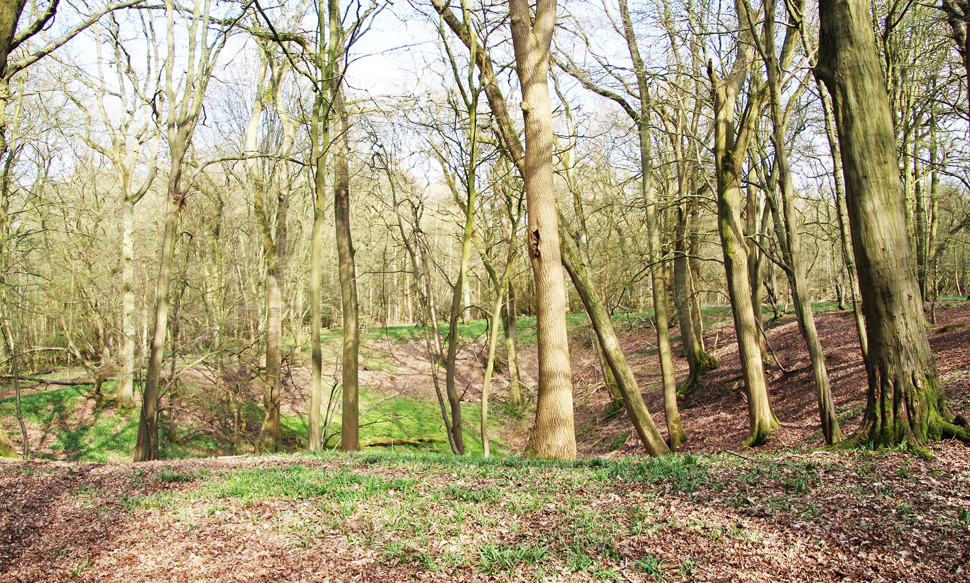
If you visit the site, you will notice in the patch of woodland on the west side of Tatmore Hills Lane, two spring-fed ponds from which flows an occasional seasonal stream down what is otherwise a dry valley leading pass the north side of Wain Wood. The woodland around these ponds is in effect a descendant of the Saxon sacred grove, whose actual origin is lost in the mists of time. When no-one else is about, the place feels slightly eerie, with a strange, almost other-worldly atmosphere.
Why was Welei deserted? There is no reference to the inhabitants of the place after 1342. Could it have been depopulated by the Black Death of 1349? It seems very likely given the devastation the epidemic is known to have caused to other local villages, such as Ashwell, Codicote, Pirton and Stagenhoe. There is a local legend that victims of the plague were buried in Wayley Close. Legend also claims that Dead Woman’s Lane by the neighbouring Sootfield Green was named after the plague victims who were buried at Wayley Close.
Wain Wood and Bunyan’s Dell
Wain Wood is recorded as Weyngdene in the 14th century. The name is Old English and means ‘sacred valley of the heathen worshippers’, clearly referring to the valley on its north side at whose head lies the ‘sacred grove of the heathen worshippers’, Welei.
The Bedfordshire Baptist preacher, John Bunyan (1628-88), author of Pilgrim’s Progress, regularly preached in Wain Wood. One reason would have been because “just above Wain Wood stood Hunsdon House (later called Preston Castle, on the site of what is now Castle Farm), the home of those six brothers Foster who long befriended Bunyan whilst preaching in these parts.” Hitchin historian, Reginald Hine (1888-1949), also wrote: “At Wain Wood, in Hitchin parish, there was no preaching shed. The cottage is still there with its pleasant ingle-nook in which Bunyan smoked many a peaceful pipe. But it was in the woodland dell which is still known as Bunyan’s Dell, under the trees and under the stars, that he preached to his ‘gathered church’ which numbered sometimes over a thousand souls. If it drenched with rain, there were four devoted women ever at hand to hold an apron over his bare head as he preached”. Preston historian, Philip Wray, writes: “Hitchin people” (and from surrounding villages) “would steal away to meet him, usually at dead of night. The chief anxiety in this district was the threat of discovery and scouts were posted on Tatmore Hills to give a warning of the approach of any officers of the law from Hitchin”.
Today, by Bunyan’s Dell (thought to be a natural amphitheatre, maybe a solution hollow, alternatively an abandoned Medieval quarry pit), one can easily imagine a congregation of hundreds of people standing in the dark, lit only by a few hand-held flickering wax candles, rush torches and horn-covered lanterns, listening intently to Bunyan’s words, striving to hear him above the wailing of the wind, beating of the rain, interrupted by the occasional hooting of owls.
Minsden Chapel
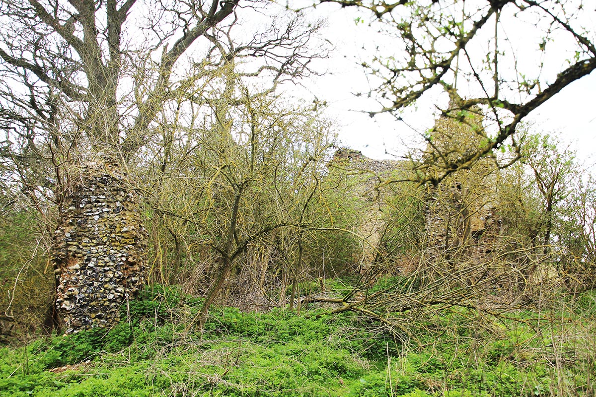
The manor of Minsden, now in Langley parish, but originally a part of Hitchin parish, is recorded in Domesday Book AD 1086 as Menlesdene, the Old English name meaning ‘Myndel’s valley’. It was assessed at 4 hides (480 acres). There was a priest, 8 villagers, 2 cottagers and 6 slaves, constituting a population of 50 – 75 perhaps. There was meadowland and pasture sufficient for the village livestock and woodland to feed 30 swine. The presence of a priest in 1086 probably indicates that there was already a church here, although the present (now ruined) chapel is thought to have been constructed around 1300. Perhaps the original church was made of timber, like the 8/9th century example discovered in Pirton in 1995. It may be that the desertion of Minsden village happened before the 1349 Black Death. It is not listed in the Lay Subsidy (tax) of 1307, although any inhabitants there could have been listed under the entry for Langley; nor is Welei, although any inhabitants there may have been listed under Dinsley. It became a chapel-of-ease to St Mary at Hitchin and served villagers from Langley and Dinsley. Services were held there, increasingly infrequently, into the 16th century and by 1650 the chapel had fallen into “great decay”. Local people began plundering the little-used chapel, looting the lead from the roof, the bells and stone from the walls. The last service was held there in 1738/9. It has continued to decay over the centuries and its chancel arch finally collapsed in 2011/12.
The ruins and site are an evocative place. In 1929 Reginald Hine wrote: “Amongst the few ‘haunts of ancient peace’ which the ruthless hand of time and the rough hands of men have spared to the inhabitants of Hitchin……there is none quite so haunting or peaceful as this neglected ruin”. Hine died in 1949 and his ashes were scattered at the chapel ruins where there is an inscribed memorial stone dedicated to him.
The ruins continue to be unstable and are now fenced off from the nearby public footpath from where they are best viewed.
Maydencroft Manor
It is first recorded in 1269 as Medcroft, Old English meaning ‘meadow croft’, but its history can be traced back to Domesday Book when it was part of the manor of Dinsley. The latter manor was divided in two in the late twelfth century which probably led to the construction of a new manor house at Maidencroft by the de Furnival family who were the owners before 1287. They gave their name to the new manor, Furnival Dinsley, to distinguish it from Temple Dinsley.
In the Lay Subsidy (tax roll) of 1307, there were 15 taxpayers in the manor of Dinsley Furnival. These represented 15 households, one being the lady of the manor and most of the others probably living in houses close to the manor house. Today earthworks are visible suggesting the former presence of buildings, property boundaries and small ponds in the pasture field between the manor house and Maydencroft Lane.
Recent research by Hitchin historian, Bridget Howlett, has established that a deer hunting park was created at Madecroft, probably in the later 14th century. It lay around the manor house on the north side of Maydencroft Lane. Close to the house is a medieval fishpond and other ponds and springs would have provided water for deer. Later field names show that Maydencroft had a rabbit warren and dovecote within the park. A single rabbit was worth more than a workman’s wage in the thirteenth century. After the Black Death of 1349, followed by recurrent epidemics, the drastic fall in population led many landowners to use part of their estates to produce luxury foods, either for their own consumption or for sale at market. In addition to venison, this included rabbits from warrens, pigeons from dovecotes, and fish, mainly bream and pike, and later carp, from ponds. The park may have ceased to exist about 1500.
According to local tradition, John Bunyan preached in the large timber-framed barn at Maydencroft, known as Bunyan’s Barn, which dates from the late 16th/early 17th century. No written records confirm this, but his followers would have gathered in secret at such locations, risking fines or imprisonment for attending a religious service not approved by the Church of England.
The present manor house dates from the 1480s with later changes and additions. There was a brewery in the house containing a furnace, a mashing vat and a yielding vat. One of the vats still exists. In the early 20th century beer was still brewed there for the farm workers. A local resident remembered the farmer brewing beer: “He used to brew beer for his men with water he got from the old pond at the bottom of his driveway. Strong brew I reckon!”.
Maydencroft Manor is private property. It may be viewed from Maydencroft Lane alongside.
Further reading:
A History of Preston in Hertfordshire by Philip Wray (2015) https://www.prestonherts.co.uk/page148.html
The Place-Names of Hertfordshire by J. E. B. Gover, Allen Mawer & F. M. Stenton (1938)
Domesday Book: Hertfordshire translated and edited by John Morris (1976)
The History of Hitchin by Reginald L. Hine, 2 volumes (1927, 1929)
Hertfordshire Lay Subsidy Rolls, 1307 and 1334 edited by Janice Brooker and Susan Flood (1998)
The Origins of Hertfordshire by Tom Williamson (2000, revised 2010)
The Knights Templar in Britain by Evelyn Lord (2002)
Medieval Parks of Hertfordshire by Anne Rowe (2009)
An Historical Atlas of Hertfordshire edited by David Short (2011)
Hertfordshire: A Landscape History by Anne Rowe and Tom Williamson (2013)
Maydencroft: A manor, hunting park and brickworks near Hitchin by Bridget Howlett (2012)
Hitchin Conservation Management Plan, Appendix 3: The Templars, Baliols and Hitchin, including results of recent archaeological work at Temple Dinsley. In memory of Christopher Sansom by Joseph Elders and Gilbert Burleigh (2010, revised 2018)